Watersheds, Runoff, and the Impact of Rain Deficits on the River-fed Lakes in Otter Tail County
When we think about healthy lakes and rivers, most of us picture clear water, good fishing, and recreation opportunities. What we don’t always see is the invisible system that supports them—the watershed. Understanding watersheds and runoff helps explain why a lack of rain during the growing season (April through October) has such a direct effect on lake levels in river-fed systems, like many of the lakes in the Otter Tail River Watershed.
Over the past few years there have been non-factual accusations about the modifications to the dams on the lakes in the Otter Tail River System causing lower water levels in the lake. Here are some facts that might help explain a little bit about fluctuating lake levels and what may or may not be causing that.
First let’s set the record straight. Yes, the dams on Big Pine, Rush, and Otter Tail Lake were modified. However, they were not removed. They were modified by being buried in rock, and boulder rapids were created downstream of the dams to allow for fish movement over the dams. 99.9% of the concrete dams in these locations are still there. The dam on Little Pine Lake was removed. However, the new boulder dam that replaced it was set at the same elevation as the old, concrete dams to maintain historic lake levels set by the MN DNR. In all cases, the engineered designs of these modifications were modeled to make sure they maintain runoff over the dams at different flow rates, based on watershed wide precipitation to make sure lake water levels were not impacted by the modifications.
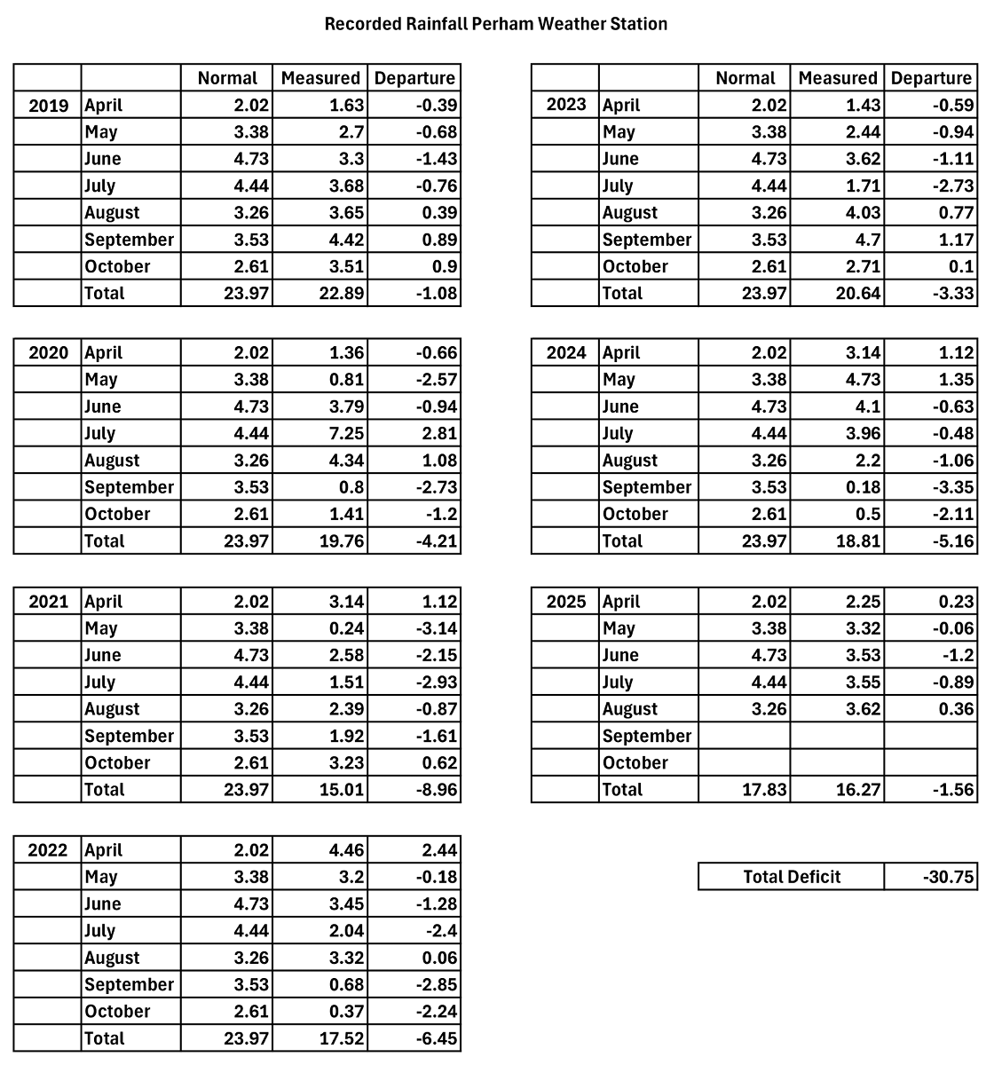
Another fact, we have a network of automated weather stations that measure various weather information including rainfall. That information can be found on the North Dakota Ag Weather Network website: https://ndawn.ndsu.nodak.edu/. Looking at historical rainfall data for the weather station located near Perham, we have been in a rainfall deficit during the growing season (April – October) every year back to 2019. In total, from 2019 to today we have accumulated a 30.75-inch rainfall deficit for that period of time during the months of our normal growing seasons. Even with the more normal rainfall this year, at the Perham weather station we are currently in a 1.56-inch rainfall deficit for the 2025 growing season. Locally, we have not received the excessive rainfall this summer other parts of the state have received.
This long-term rain deficit is having a negative impact on all the wetlands, streams, & lakes in our watershed. This long-term rain deficit is the reason for the lower water levels we have been experiencing over the past several years. To explain that a little more, here is some more information about watersheds and how runoff works.
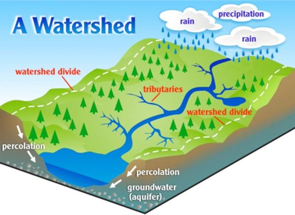
What is a Watershed?
A watershed is an area of land where all the rain and snow that falls drains into the same place—streams, rivers, wetlands, or lakes. Watersheds come in all sizes, from the tiny creek behind a house to the massive Mississippi River Basin. Everything that happens on the land within a watershed influences the water downstream.
How Runoff Works
When rain falls, it can do three main things:
1. Infiltrate into the soil – supporting crops, lawns, grasslands, and forests, or recharging wetlands and groundwater.
2. Evaporate back into the atmosphere.
3. Run off the land surface into wetlands, ditches, streams, and rivers, eventually reaching lakes and oceans.
Rain Deficits During the Growing Season
The growing season, April through October, is when plants actively use water. Farmers’ crops, trees, and grasses take up large amounts of soil moisture to grow. In fact, corn crops at maturity can use over 1/4 of an inch of water a day through evapotranspiration.
During this time:
- A normal amount of rain replenishes soil moisture, and dry wetlands first, then any additional rainfall runs off into streams, rivers, and lakes.
- A rain deficit means the soil and wetlands never get fully recharged. Instead, most of the limited rainfall is absorbed by plants and lost to evaporation. Very little, if any, is left over to become the runoff that replenishes the streams & lakes in the watershed.
This has two major consequences:
- Lower River Flow – With less water reaching streams and rivers, the flow rate drops.
- Falling Lake Levels – River-fed lakes depend on steady inflow. Without runoff, inflows decline, and water levels can drop significantly.
Evaporation
Another thing most people don’t realize is the amount of evaporation that happens from the surface of lakes. We are not going to do the math, but our lakes are losing millions of gallons of water through evaporation, removing water that is not being replenished from rainfall runoff. This vast amount of evaporation drives even lower lake levels.
The Big Picture
Rainfall is not just about keeping crops growing or our lawns green, it drives the entire water cycle of a watershed. When April–October rains are below average, the impacts ripple across ecosystems, affecting the water levels in our wetland, rivers, and lakes. Dams, even the newly modified dams which were built to help maintain historic water levels, don’t add water to our watershed systems, they just prevent more from running out of the lake. In times like this, when we have had several years of continued rainfall deficits, lake levels are going to be impacted and will be lower than normal because we don’t have the runoff from our watershed to refill our lakes.
It is understandable when shoreland owners, and other lake visitors are frustrated with the issues caused by lower water levels, and they look for something to blame, but let’s look at the real reason behind the issue and not blame something that isn’t the cause. Mother Nature has had way more impact on the water levels of our lakes than we give her credit for. The next time you hear or see someone blaming the dam modifications for the lower water levels we are experiencing, please educate them on the facts, over the past seven years rainfall records show we have an accumulated 30.75-inch rainfall deficit during the growing seasons of April – October. Less rainfall equals less runoff which equals lower water levels in our streams and lakes.
Let’s all hope for more normal rainfall and lake levels over the next few years.
Posted in: News